Tag: Orange Line

Comment Letter: Tremont Crossing Draft Environmental Impact Report MEPA #14900

Comment Letter: Tremont Crossing Draft Environmental Impact Report MEPA #14900

November 23, 2016

Matthew Beaton, Secretary
Executive Office of Energy and Environmental Affairs
Attn: MEPA Office
Analyst: Erin Flaherty
100 Cambridge Street, Suite 900
Boston, MA 02114

RE: Tremont Crossing Draft Environmental Impact Report  MEPA #14900

Dear Mr. Beaton,

WalkBoston has reviewed the DEIR for the Tremont Crossing proposal in Roxbury. We believe that the very auto-oriented proposed development is inconsistent with the urban character of the neighborhood and needs to be substantially modified to benefit its neighbors.

Parking Spaces Proposed are Excessive
The development calls for a multi-level parking garage of 1,371 spaces that will generate 8,000 vehicle trips per day.  WalkBoston questions the need for such a large garage given that the development will be less than two blocks from Roxbury Crossing and Ruggles Transit Stations, and within a 10-minute walk of Dudley Square that is served by twenty bus lines.

By comparison the two large Target Stores in the Fenway (Boston) and Cambridge have only a couple of hundred parking spaces.  Numerous parking studies of big box stores and shopping malls throughout the country have shown that parking lots/garages are underutilized.

The emphasis on parking and downplaying of the use of transit suggests an imbalance for so large a project in the heart of the city.   As stated in the 2012 comment letter from Boston Transportation Department a consistent supply of available parking will counteract efforts to encourage alternative travel modes.

Tremont Street Should Not Be Widened
To accommodate the large number of vehicles accessing and exiting the proposed development Tremont Street is projected to be widened to eight or nine lanes.  Such a wide roadway at this location is incompatible with the urban character of the street and will create safety hazards to the pedestrians and bicyclists moving to and from the transit services, residences and institutions.

Also, the environmental review should include an assessment of the impact of increased traffic on the busway at Ruggles.  Numerous buses leave Ruggles headed for Dudley and WalkBoston has concern that at peak hours buses will be waiting through numerous traffic signal cycles to exit unto Ruggles Street.  The result could be a backlog of congestion from Ruggles to Malcolm X Boulevard.

Roxbury Crossing Development Should be Integrated into the Neighborhood
As currently designed, the development will be an island, separated from its neighborhood setting.  The proposed development has the opportunity to contribute to the street by creating easy walking access from the transit stations as well as nearby residential developments (Madison Park and Whittier Housing) and institutions (Northeastern University).  The Tremont Street Development is located in an area where Transit Oriented Development is particularly appropriate.

Proposed Project Could Acknowledge Changing Retail
The retail environment has changed since the project was proposed 4 – 5 years ago.  More and more shopping is done on line and traditional walk-in retail is struggling.  Evidence of this is in Dudley Square, the heart of Roxbury.  WalkBoston would like to see the City devote greater efforts to supporting viable retail in Dudley.  Promoting retail within a 10-minute walk of Dudley will only further depress the market for shops in Dudley Square.  However even within the proposed development the liveliness of the retail is questionable given that the proposed network of bridges will connect the garage on the second floor, discouraging patronage of the ground level retail.

Ensure Safety of Major Pedestrian Crossings.
The major pedestrian crossings of Tremont Street will take place at intersections with Ruggles/Whittier Street, South Drive and Prentiss Street. The primary crossing is likely to be at Ruggles/Whittier Street, because of the direct access it provides to the Ruggles MBTA Station. Care should be taken to provide for significant numbers of people wanting to cross Tremont Street at this location. Retention of the median strip in the center of Tremont Street would be useful as a refuge for pedestrians who may not be able to cross the entire width of a widened Tremont Street in one signal cycle. Similarly, leading pedestrian signal intervals should be incorporated to facilitate safe pedestrian crossings at the intersection. Analysis should also be undertaken to determine if a crosswalk is truly needed at South Drive, in view of the nearby Prentiss Street crossing.

Thank you for the opportunity to review this proposal. Please feel free to contact us with questions you may have, and we look forward to hearing how our suggestions are incorporated into subsequent revisions to this plan.

Sincerely,

Wendy Landman
Executive Director

Dorothea Hass
Sr. Project Manager

cc: Councilor Tito Jackson
Byron Rushing, State Representative
Deirdre Buckley, MEPA Director
Dana Whiteside, Boston Planning and Development Agency
Kay Matthews, Friends of Melnea Cass Boulevard (FMCB)
Marah Holland, FMCB
Alison Pultinas, FMCB

 

“The Old State House corner: The corner that could”

“The Old State House corner: The corner that could”

image

The time capsule on top of the Old State House was recently in the news. But did you know about more recent history on that corner?

Bob Sloane recently wrote in our newsletter about changes that WalkBoston pushed for on the corner in 2011 that helped get wider sidewalks and improve safety for the over 36,000 people cross that spot daily between T station users and visitors on the Freedom Trail.

Haven’t received your newsletter yet? (We mail it out to supporters). Get in touch with us or make sure to make your contribution today!

————————————————————————————————

Join our Mailing List to keep up to date on advocacy issues.

Like our work? Support WalkBoston – Donate Now!
Connect with us on Twitter and Facebook

Lessons Behind Somerville’s New T Stop

Lessons Behind Somerville’s New T Stop

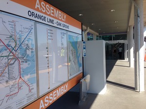
Assembly Station - photo by Glen Berkowitz“New transportation by itself is not a miracle cure for urban blight. Zoning, permitting, street configurations, active transport options, parks, schools, policing, trees, public art, public engagement – all of those things tend
to be part of the solution.”

– Somerville Mayor Joseph Curtatone 

Congratulations to MassDOT and the MBTA on the opening of Assembly Station – it is wonderful to see an addition to the transit system which will help create such enormous economic opportunities and help achieve the mode shift goal which is such a key to Massachusetts’ future. Somerville Mayor Joseph Curtatone’s CommonWealth Magazine article is absolutely on target. (Photo by Glen Berkowitz).

Read the full article

—————————————————————————————————

Join our Mailing List to keep up to date on advocacy issues.

Like our work? Support WalkBoston – Donate Now!
Connect with us on Twitter and Facebook


Comments on the Final Environmental Impact Report for the Wynn Everett Development, MEPA# 15060

Comments on the Final Environmental Impact Report for the Wynn Everett Development, MEPA# 15060

August 8, 2014

Secretary Maeve Vallely Bartlett
Executive Office of Energy and Environmental Affairs (EEA)
Attn: Anne Canaday
100 Cambridge St., Suite 900
Boston MA 02114

RE: Comments on the Final Environmental Impact Report for the Wynn Everett Development MEPA# 15060

Dear Secretary Vallely Bartlett:

WalkBoston has reviewed this document, in keeping with what we have done for other projects across the state, looking for potential mplications for pedestrians as a result of the proposal. We offer the following comments.

Access to the site as a pedestrian 
The Final Environmental Impact Report (FEIR) for the Wynn Everett Development includes changes in the program between the DEIR and the FEIR. Changes that were introduced reduce the square footage devoted to the hotel, retail space, and convention services and enlarge the gaming areas, food/beverage service areas, entertainment/nightclub areas and support areas. Total square footage of the development has risen from 2,619,234 to 3,038,695 square feet. A total of 3,200 slot machines and 160 gaming tables are proposed, along with a 504-room hotel. The number of parking spaces under the complex has been increased and will house 3,700 cars on-site and 800 off-site.

• The use of public transportation is not encouraged by the present plan. Arrivals by vehicle are emphasized. The project is estimated to generate 9,424 vehicle trips on a Friday. Fewer people will arrive by public transportation – estimate at 3,265 public transportation person trips and 1,454 additional trips if water transportation is provided. (it is unclear where the water transportation riders go if water transportation is not provided, and this analysis should be provided if the proponent does not contractually commit to providing water transportation service.)

• Estimates of the use of public transportation conclude that capacity on public transportation is available, suggesting that more use of public transportation could be encouraged. Bus routes that serve the site generally have excess capacity (although estimates are that use will exceed capacity of Routes 104 and 109 outbound at certain times. Given the capacity available, there are no suggestions of making greater use of bus services on Alford Street at the site entrance or of enhancing capacity on Routes 104 and 109. Orange Line riders are also projected to be accommodated by available capacity. Shuttle service to the site from the Orange Line Sullivan Square Station is proposed, and, if adequately promoted, may at some point in the future result in more patrons arriving by public transportation.

• Walk-in traffic is not encouraged by the present plan. Walk-ins to the site include public transportation riders as well as nearby residents or employees. We are concerned that the pedestrian access may be unattractive to walkers. Sidewalks along both sides of the entrance drive are not afforded the lavish landscaping and improvements that surround paths along the water. Walk-in customers are not anticipated from the west side of the tracks, though a potential route is to be provided.

• A portion of the riverside might be used for additional pedestrian access. Immediately adjacent to this property, and also along the Mystic River, are lands owned and occupied in part by public agencies that front on Route 99. The proponent should explore with these agencies the potential for riverside access for pedestrians, in effect extending the Mystic River pathway network closer to Sullivan Square and making the walking routes much more attractive. The riverside route could be an attractive alternative for walkers to reach the proponent’s property away from the heavy traffic on Route 99.

The on-site paths are major links in the East Coast Greenway/Northern Strand/Bike to the Sea rail trail.
Although the proposal does not encourage access by pedestrians, it does include a very good proposal to extend the on-site walkways into the adjacent Gateway Park. Plans are in place for a regional multi-purpose path between downtown Boston and the New Hampshire state line. Called the Borders to Boston Trail, this route is 28 miles long and traverses 8 communities. Everett has constructed a portion of the path that is currently the southern end of the trail. A link across the Mystic River is required to access Boston. One proposal was to construct a pedestrian bridge over the Mystic River between Everett and Somerville. The engineering study done for this connection resulted in a finding that there was no feasible crossing at this location at an acceptable cost.

The alternative to a new and costly bridge is a connection directly through the proponent’s site. The route would connect Gateway Park’s riverside paths through the proponent’s site, where the route would link with bike paths and sidewalks along Alford Street to gain access into Boston. As it becomes a link in a major-north-south bicycle and pedestrian route, it will need careful attention to design details in the path proposed by the proponent. For a multipurpose path of this importance, a clear width of 10’ may be inadequate to accommodate likely numbers of walkers, joggers and cyclists. The route across the site should be investigated to assure that potential users of the site’s waterfront will not be adversely affected by the multi-purpose path. Access at the Alford Street intersection should also be investigated to assure safety for pedestrians and cyclists who may be crossing to get to the site.

Off-site improvements
The proponent has committed to improve several roadways near the site. Alford Street will clearly be in need of improvements because of impacts from this proposal. Alford Street will also need appropriate pedestrian signal equipment (automatic WALK signals during times of day when pedestrians will be present, countdown signals, leading pedestrian indicators, and signal heads at each intersection). Refuge islands at the street centerline should be considered. Crosswalks will need fresh zebra striping, possible curb extensions and potential addition of in-street crosswalk “yield to pedestrian” signs.

Thank you for the opportunity to comment on this important project.

Sincerely,

Wendy Landman              Robert Sloane
Executive Director            Senior Planner

—————————————————————————————————

Join our Mailing List to keep up to date on advocacy issues.

Like our work? Support WalkBoston – Donate Now!
Connect with us on Twitter and Facebook

Comments on the DEIR for the Redevelopment of the Government Center Garage MEPA #15134

Comments on the DEIR for the Redevelopment of the Government Center Garage MEPA #15134

July 11, 2014

Secretary Maeve Vallely Bartlett
Executive Office of Energy and Environmental Affairs (EEA)
Attn: Holly Johnson
100 Cambridge Street, Suite 900
Boston MA 02114

RE: Comments on the DEIR for the Redevelopment of the Government Center Garage MEPA #15134

Dear Secretary Vallely Bartlett:

WalkBoston reviews significant proposed development projects to provide comments about their impacts on pedestrians, and to suggest measures that may mitigate negative impacts or generally improve the projects for walkers.

We have reviewed the DEIR for the Redevelopment of the Government Center Garage and find exciting aspects of the project that will benefit walkers. These include:

Enhancement of a major pedestrian-transit hub
The East Parcel contains a high-volume transit hub with extensive pedestrian access. Access to the Orange and Green Line Haymarket Station access points will be maintained, as will access to the many MBTA bus services. Some of the difficult pedestrian crossings to the site will be improved by narrowing the width of the New Sudbury Street and thus the length of the crosswalks at its intersection with Congress Street.

The sidewalk through the East Parcel
The new pedestrian connection proposed for this project between Congress Street and Canal Street respects a traditional walking route between Downtown and North Station. This route will see more intensive use over the coming years as the significant developments at North Station and at this site occur, and the proposed design reflects the many circulation activities that are required of this parcel.

A new signalized intersection for Bowker Street
The proposed signalized intersection at New Chardon Street and Bowker Street is a welcome addition for pedestrians. The nearby intersection of New Chardon and Congress Street is skewed in such a way that the crossing is very long and is inconvenient for walkers going to the courthouse across the street. The new crosswalk makes the move much more convenient.

Improvements to on-site parking
As parking ceases to be the principal use of this site, the plan is much less auto-oriented. A reduction of number of available parking spaces reduces vehicles circulating around the site for access. This is accompanied by a reduction in the number of places where vehicles must cross sidewalks, enhancing pedestrian safety. The removal of garage access from New Chardon Street and its potentially busy sidewalks is a major pedestrian benefit of the proposal.

In addition to these project benefits, we also note several issues that need more attention.

Weather protection for walkers
The current garage has the unusual benefit of covering the bus waiting area and access to the transit station below, thus protecting walkers from rain and snow. Removing the garage and opening up the area for new development is beneficial to the project, and we believe that Figure 1.8 shows that the new structure will also provide cover for the bus station area. However, no cover for the subway entrance area is shown. The diagrams are less than clear on this point and we ask the developer to clarify how the bus waiting area and subway entrance areas will be designed and whether they will be covered.

Widths of sidewalks
Pedestrian improvements included in the project will improve safety at crosswalks and along the major streets. A note suggests that the current sidewalks widths are varied throughout the project, and are “rarely less than eight feet wide.” We trust that the standards for future sidewalk widths in this pedestrian-friendly project will be considerably wider and in keeping with the City’s complete street guidelines.

Services provided at the bus station
Six bus stops are proposed in the redesign of the bus station. Three of the stops will be in the area where they are now located, and three stops will be provided by a nominal widening at the side of the Central Artery Surface Road. The design and operation of the bus stops is critical for pedestrian safety and convenience. We ask that the proponent provide detailed diagrams and sketches of how this area will operate and ensure that bus patrons are well served by the new design.

Truck loading bays facing New Chardon Street
New Chardon Street is the major Downtown/North End access to and from the Central Artery (I-93). Four truck loading docks are proposed for the section of New Chardon between Congress Street and the on- and off-ramps leading to the I-93. The site plan suggests that trucks will back into these docks from the street travel lanes across the sidewalk on this side of the East Parcel. Unless use of the docks are restricted to the middle of the night it is difficult to comprehend how trucks backing into place across the sidewalk on a ramp to I-93 can be safely accommodated. We request that the proponent describe this element of the project in detail, including how pedestrian safety will be maintained.

Cut-ins on sidewalks
Cut-ins are proposed on three sides of the East Parcel and two sides of the West Parcel:
1. New Seabury Street near the Surface Artery
2. New Chardon Street near Canal Street
3. New Chardon Street near Bowker Street
4. Congress Street Near New Sudbury Street toward Leverett Circle
5. Congress Street near New Sudbury Street toward State Street

Although not well defined in the DEIR, a cut-in appears to be a pull out lane that reduces the width of the sidewalk to accommodate vehicles. The drawings in the DEIR show these indentations only vaguely but imply that a cut-in is a lane for vehicles separate from the adjacent thoroughfare but parallel to it.

The next stage of development of the project should include details of:

  •  Why the cut-ins are needed in each of the five locations?
  • How they are proposed to be used (back-in, parallel movement, etc.)?
  • How they relate to, or potentially conflict with, all major adjacent pedestrian flows?
  • Design guidelines that include minimum widths for adjacent sidewalks or crosswalks, as well as bollards or other protections for walkers. We are concerned that the sidewalks seem quite narrow adjacent to some of the proposed cut-ins.

We appreciate your consideration of our comments and look forward to your responses to them. Please feel free to contact WalkBoston with questions you may have.

Sincerely,

Wendy Landman                                 Robert Sloane
Executive Director                              Senior Project Manager