Tag: runner

Comment Letter: A proposal for the Massachusetts Avenue Bridge

Comment Letter: A proposal for the Massachusetts Avenue Bridge

September 19, 2016

Mayor Martin Walsh, Boston
Mayor Denise Simmons, Cambridge
Stephanie Pollack, Massachusetts Secretary of Transportation
Tom Tinlin, Massachusetts Highway Administrator
Leo Roy, Massachusetts Commissioner, Department of Conservation and Recreation
Monica Bharel, Massachusetts Commissioner, Department of Public Health

Re: A proposal for the Massachusetts Avenue Bridge

Dear Friends:

Boston and Cambridge have declared themselves Vision Zero cities. The Healthy Transportation Compact has united our state agencies in concerted efforts to increase active transportation and improve safety for walking and bicycling.

DCR is on track to add a new Charlesgate Path and a signalized pedestrian/bike crossing of the Mass Ave Bridge to connect the Esplanade with the Back Bay/Kenmore neighborhoods (the crosswalk will be located where the Mass Ave. Bridge crosses the open space between inbound and outbound Storrow Drive). The new Charlesgate path, and the enhanced connection between the Esplanade and Charlesgate via the new crosswalk will generate significant new use by people walking and biking.

These are wonderful developments for people from across Massachusetts and the world who commute, amble and sightsee on the Esplanade, along Memorial Drive, and across the Massachusetts Avenue Bridge! And, they are all leading to more people on foot and bike on the bridge.

As we see the increase in people walking and biking, the lack of safe biking accommodation on the Mass Ave Bridge is leading to large numbers of bicycles on the sidewalks of the Bridge – an unsafe and uncomfortable situation.

We ask that MassDOT, DCR, Boston and Cambridge explore the re-purposing one of the outbound Mass Ave Bridge vehicle travel lanes to provide space for a protected bike lane on each side of the bridge, with access provided from the Esplanade and Charlesgate paths that will connect to the Bridge.

Based on a very preliminary look at the traffic volumes and lane use on the Bridge, we believe that improving the network by adding low-stress, protected bicycle lanes could be accomplished without significant impacts to vehicle operations. Providing protected bike lanes will both improve the safety of people on bikes and improve the safety of pedestrians by removing bicycles from the Bridge sidewalks.

We look forward to working with you and your staff to explore this suggestion.

Best regards,

Wendy Landman, Executive Director, WalkBoston
Tani Marinovich, Executive Director, The Esplanade Association

Cc Senator Will Brownsberger
Senator Joseph A. Boncore
Representative Jay Livingstone
Chris Osgood, Chief of Streets, City of Boston
Gina Fiandaca, Boston Commissioner of Transportation
Joe Barr, Director of Traffic, Parking, and Transportation, City of Cambridge
Becca Wolfson, Executive Director, Boston Cyclists Union
Stacy Thompson, Executive Director, LivableStreets Alliance
Richard Fries, Executive Director, MassBike
Herb Nolan, Solomon Fund
Renata von Tscharner, Charles River Conservancy
Peter Furth, Northeastern University
Suzanne Walmsley, Boston Athletic Association

Under the US Department of Transportation’s (USDOT) current draft regulations, states won’t be required to distinguish between different roadway users (“motorized” and “non-motorized” users in agency language). That makes for a one-size-fits-all approach, with no room for targeted strategies to improve safety for pedestrians.

Non-motorized fatalities represent 14 – 16 % of national traffic deaths — up from 12 % just a few years ago — an alarming trend hidden in the overall decrease of traffic fatalities.

Until June 9, 2014 USDOT is accepting comments on its current draft of these rules. Tell USDOT to get serious about pedestrian safety; remind Secretary Foxx that not everyone gets lucky like he did (see his quote above).

Smart Growth America has drafted a letter that addresses pedestrians and the need for state accountability on safety – 

You can also read our comment letter on USDOT Performance Measures here, or write about the issue in your own words and send a letter to:

Secretary Foxx
U.S. Department of Transportation
Docket Operations
M-30, West Building Ground Floor, Room W12-140
1200 New Jersey Avenue SE
Washington, DC 20590

Comments on the Environmental Notification form for the second phase of the Clipper City Rail Trail Phase II in Newburyport and Newbury, MA MEPA# 15191

Comments on the Environmental Notification form for the second phase of the Clipper City Rail Trail Phase II in Newburyport and Newbury, MA MEPA# 15191

May 12, 2014

Richard K. Sullivan, Jr. 
Executive Office of Energy and Environmental Affairs
Attn: Alex Strysky
100 Cambridge St., Suite 900
Boston MA 02114

RE: Comments on the Environmental Notification form for the second phase of the Clipper City Rail Trail Phase II in Newburyport and Newbury, MA MEPA# 15191

Dear Secretary Sullivan:

WalkBoston has reviewed the Environmental Notification Form for the Clipper City Rail Trail Phase II, which calls for a new multi-purpose trail on a 1.5 mile section of former rail property – the old City Branch line – in the eastern part of the city. Phase II will also extend along a significant portion of the Merrimack River waterfront in the city center. This new trail adds to the existing 1.1 mile rail trail (Phase I) which links the MBTA commuter rail station and Merrimack River not far from the center of the city. A later Phase III will join these two segments in the vicinity of the existing commuter rail station south of the city, but not along the Merrimack River.

Our review leads us to offer these comments:

Design the trail for expansion 
The proposal for Phase II includes an 8-10 foot wide path. The right-of-way for the trail is irregular, as it passes through publicly owned land that includes 19.4 acres. With this space, plans should recognize the possibility that the path will need to be widened if it is successful in drawing users. Many rail trails in Massachusetts are 10-12 feet wide, permitting a 5-6 foot path in each direction. For example, an extension of the Bruce Freeman Trail in Acton will provide a 12-foot trail with 2-foot wide shoulders on both sides to allow space for pedestrians to step aside from other users of the path if they feel the need to let them pass (a possibility if bicycles are passing).

Design the rail trail to include runners 
Rail trails are a success in Massachusetts. Concurrent with the growth in use, new paths need to be carefully designed to serve a wide variety of users. Phase II of the Clipper City Rail Trail appears to be a very desirable facility, and it makes sense to design it to accommodate runners who are frequent users of trails. Runners often prefer a softer surface than that favored by cyclists and walkers; stone dust has frequently been used because it is resilient and provides a comfortable running surface.

Phase II of the Clipper City Rail Trail has significant right-of-way space that would allow more than a basic bicycle and pedestrian path. With space available, a parallel running track should be considered for the Trail. Even if such a running track is a future addition to the facility, space for such a track should be preserved for the future. In a state known around the world for the Boston Marathon and the many sponsored running events, runners should be included, along with the walkers and bicyclists who may be the prime users of the proposed facility.

Connecting Phase I and Phase II in the city center 
Plans for connecting Phase I and Phase II of the Trail along the Merrimack River in the waterfront area of Newburyport are not included in this document. Omitting mention of such a potential connection seems to diminish the potential created by Phase II construction. Phase II, paralleling the Merrimack River, terminates at Custom House Way, at a point that appears to be adjacent to a portion of the existing Waterfront Promenade Park. This open space has a seawall and boardwalk that can extend the walk two to three blocks further west. Admittedly, at the western end of Promenade Park, an off-street right-of-way may be difficult to find. Sidewalks may have to be used to pass along these few blocks, but if completed, this connection between Phase I and Phase II would afford a 2.4 mile loop around many of the older portions of the city.

Thank you for the opportunity to comment on this important project.

Sincerely, 

Robert Sloane 
Senior Planner

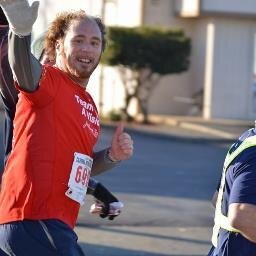
Blind man walking (and running)!

Blind man walking (and running)!

image

Kyle Robidoux is the Director of  Volunteer & Support Group Services at the Mass. Assoc. for the Blind & Visually Impaired.

I walk everywhere. As a marathoner, I also run all throughout Boston and neighboring cities.

I’m also legally blind so walking, along with public  transit, is my main mode of transportation. Therefore,  walkability is very important to me and my family.

The walkability of the city and its public infrastructure impacts me every day. It impacts where I walk, how quickly I can get to where I need to be, and most importantly how safely I can get there.

As someone with low vision (I have very restricted central vision, similar to looking through a toilet paper roll), I rely on sidewalks, curb cuts and ramps, and crosswalks to get me safely to where I need to be. I use a white cane most of the time so the quality of sidewalks and streets is very important.

Brick sidewalks are one of the most unfriendly surfaces for me and most folks with limited mobility (I assume most sighted walkers, too). My cane tip frequently gets stuck in a missing brick or I trip because of the unevenness of the sidewalk. Old (some say historic) sidewalks are very common in the South End, where I spend a good majority of my time. If I have a choice, I will avoid going down a street if I know it has terrible brick sidewalks. I’m thankful that the city has set a new policy limiting the amount of brick in the walk path when repairing/installing new sidewalks.

As my eyesight decreases, I am becoming more reliant on audible street crossings. Otherwise, I have to ask someone to help me find the push button. It would be wonderful if more street crossings had regular intervals in which to cross or a “walk signal” triggered by a sensor on the closest curb ramp.

My relationship to the built environment in my neighborhood plays a large factor as my eyesight decreases, especially during the winter. Trying to navigate unshoveled sidewalks and curb cuts blocked by snowbanks is physically and mentally exhausting. I walk my daughter to school along the South Bay Harbor Trail. Sections of the trail were not plowed this winter days after a snowstorm. Some days my daughter and I, along with other students, were forced to walk in the street because the unplowed path was too difficult to walk.

As our communities continue to develop, I hope less time and energy is spent on talking about parking and traffic and more on creating accessible public spaces.

Creating accessible spaces is not only good public policy but will also ensure that they flourish and reach their greatest potential.

This article was featured in our Spring 2014 newsletter. See the full newsletter & past editions here.

——————————————————————————————————————-
Join our Mailing List to keep up to date on advocacy issues.

Like our work? Support WalkBoston – Donate Now!
Connect with us on Twitter and Facebook

Comments on the Environmental Notification form for Bruce Freeman Rail Trail Phase 2A MEPA# 15196

Comments on the Environmental Notification form for Bruce Freeman Rail Trail Phase 2A MEPA# 15196

May 12, 2014

Richard K. Sullivan, Jr.
Executive Office of Energy and Environmental Affairs
Attn: Holly Johnson
100 Cambridge St., Suite 900
Boston MA 02114

RE: Comments on the Environmental Notification form for Bruce Freeman Rail Trail Phase 2A MEPA# 15196

Dear Secretary Sullivan:

WalkBoston has reviewed the Environmental Notification Form for the Bruce Freeman Rail Trail Phase 2A. The project will extend the existing rail trail 4.88 miles further than the existing trail that begins in Lowell. The new segment passes through Westford, Carlisle and Acton, with much of the project in the Town of Acton. It is encouraging to see this facility being extended into additional communities.

We are especially thankful that the proposed construction includes 2-foot wide shoulders on both sides of the 12-foot wide path, and that an adjacent 6-foot wide stone dust trail is a feature of the project. Both of these additions to the trail will add immeasurably to the use and enjoyment of the path by pedestrians and, in particular, by runners.

Rail trails are a growing success in Massachusetts. Concurrent with the growth in use, the paths have become somewhat overcrowded with conflicts between users, particularly between pedestrians and bicycles. Runners have too often not even been considered for a special facility in prior path designs.

The new 2-foot wide shoulders on both sides of the 12-foot wide path will provide space for pedestrians to step aside from other users of the path if they feel the need to let them pass (a possibility if bicycles are passing).

The 6-foot wide stone dust path that will be constructed alongside the rail trail is a very worthwhile addition to the facility. This, too, is a significant advancement for rail trail construction in Massachusetts. Runners will now have their own space, removed somewhat from walkers and totally separate from bicycles, rendering a path that is likely to be unobstructed by other users. The use of stone dust for this portion of the trail is also a distinct advancement beyond most other trails in the state. This material is softer and more resilient for use by runners, and helps in providing a more comfortable way to run, thereby enhancing the experience for runners who use it.

The new construction techniques incorporated into this trail set a standard that certainly bodes well for future construction of rail trails and other running/walking/biking facilities in the Commonwealth. We advocate for the issues of pedestrian safety and comfort in crowded rail trails, and have additionally been advocating for specific facilities for runners in each of the trail corridors for runners’ safety and comfort. These new standards of trail construction will lead to facilities that can accommodate additional users and help them be confident that their specific concerns are reflected and that a mix of users will feel  comfortable and secure in using the trails.

Thank you for the opportunity to comment on this important project.

Sincerely,

Robert Sloane
Senior Planner